


Parrot, the leading European drone group, announced it is partnering with RIIS, a leading provider of mobile app, web development and IT consulting services, to develop custom applications of artificial intelligence for Parrot's popular ANAFI drone platform. Parrot and RIIS are focused on exploring the use of artificial intelligence and computer vision technology, combined with drone data capture, to solve countless industry challenges using an efficient and cost-effective approach.
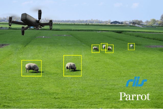
To help demonstrate the promise of this technology and allow developers to start creating innovative apps, Parrot and RIIS have released a technical whitepaper, which provides step-by-step instructions to add AI and computer vision to the ANAFI Drone using Parrot's open-source Ground SDK.
"We are excited to explore the immense capabilities AI and drones will deliver to our clients through our ongoing partnership with RIIS," said Jerome Bouvard, Parrot Director of Strategic Partnership. "At Parrot, we are always looking for innovative solutions to so for our enterprise partner's every-day pain points."
Parrot and RIIS are actively exploring use cases which could include municipal use of drones for assessing parking lots, public parks, and streetlights; crowd monitoring; warehouse inventory counting; automated inspection of cell phone towers and solar panels; property surveillance for real estate professionals and developers, and much more. This technology is expected to significantly enhance the often-tedious processes required to complete professional projects across a variety of industries and sectors.
"Our recent collaboration with Parrot perfectly illustrates the immense potential of developing apps for Parrot's ANAFI drone platform," said RIIS CEO and Founder Godfrey Nolan. "Leveraging the power of AI and mahine learning apps with Parrot drones promises to provide previously impossible solutions to costly and time-consuming challenges.
Parrot and RIIS' whitepaper details one example of this technology in practice through an application called Cattle Counter. The app allows farmers and agriculture professionals to effortlessly and accurately quantify the size of cattle herds to automate the monitoring and counting process. Cattle Counter is currently available for download on the Google Play website.
Through its SDK Partner program, Parrot is working to create a global ecosystem of drone apps to serve the unique and ever-evolving needs of its enterprise and professional users. Through this program, Parrot is working with partners, like RIIS, to create and bring to market new applications, software and hardware that seamlessly integrate with Parrot ANAFI and ANAFI Thermal drones.
Source: https://surveyinggroup.com/en/ai-programs-for-anafi-drone-platform/
On January 6, 2020, at the Faculty of Geomatics and Land Administration, the Dean had a meeting with Professor Oh Jae Hong of Korea Maritime University. Attending the meeting were Dr. Tran Thuy Duong - Dean, Assoc. Prof. Dr. Bui Ngoc Quy, Assoc. Prof. Dr. Nguyen Van Sang - Vice Dean and other teachers in the department. At the meeting, Professor Oh Jae Hong introduced about Korea Maritime University in general and the Department of Engineering in particular as well as the opportunities to study here for Geodetic and Cadet students.
Assoc.Prof. PhD Tran Xuan Truong - President of Ha Noi University of Mining and Geology Council, Representative alumni of Photogrametry, Course 38
Author: A/Pro.PhD Nguyen Truong Xuan, Science and Technics Publishing House, 2014
Author: A/ Prof. PhD Nguyen Truong Xuan, Publishing house of Science Nature and Tecnology, 2012
Authors: Prof.PhD Truong Anh Kiet, A/Prof.PhD Pham Vong Thanh - Transport Publishing house, 2009
The 30th International Cartographic Conference (ICC 2021) will take place in Florence, Italy, 19–23 July 2021.
The 30th International Cartographic Conference will take place in Florence, Italy, 19–23 July 2021
22-26 April 2019 Hanoi, Vietnam
The FIG Asia Pacific Capcity Development Network (AP CDN) were invited by the President of the United Nations Global Geospatial Information Management for Asia and the Pacific (UN GGIM AP), to participate in its 8th Plenary Meeting held in Canberra – Australia on 3-5 November 2019. This Plenary Meeting was the first meeting convened under the Presidency of Australia, and was organised by the agency Geoscience Australia and also the secretariat, United Nations Economic and Social Commission for Asia and the Pacific (UN ESCAP), who are presently based in Bangkok, Thailand.
Parrot, the leading European drone group, announced it is partnering with RIIS, a leading provider of mobile app, web development and IT consulting services, to develop custom applications of artificial intelligence for Parrot's popular ANAFI drone platform. Parrot and RIIS are focused on exploring the use of artificial intelligence and computer vision technology, combined with drone data capture, to solve countless industry challenges using an efficient and cost-effective approach.

FACULTY OF GEOMATICS AND LAND ADMINISTRATION - UNIVERSITY OF MINING AND GEOLOGY
Address: 10th Floor, Building C12, University of Mining and Geology, N0 18 Vien Street, Duc Thang, Bac Tu Liem, Ha Noi, Vietnam
Office phone: +8424.38 38.7568
Email: tracdiabando-quanlydatdai@humg.edu.vn
© 2020 - Copyright by Faculty of Geomatics and Land administration